Introduction – A short introduction to land pattern in Karnataka ( 15 words)
Body – Explain about Land Utilization in Karnataka (120 words)
Conclusion – Mention a short conclusion (15 words)
ANSWER
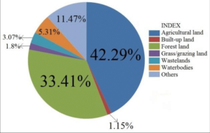
Use of land for various purposes is called land utilisation. Karnataka's geographical area of 1,91,791 Sq.km. constitutes 5.83% of India's geographical area.
PATTERN OF LAND UTILIZATION IN KARNATAKA
1. Net area sown: The distribution of net area sown is not the same all over the state. Gulbarga district has the largest area under cultivable land in the state. It is followed by Belagavi, Vijayapura, Tumakuru, Raichur, Bagalkot, Ballari, Chitradurga and Mysuru districts. Bengaluru district has the least net area sown, due to wide-spread urbanization. Uttara Kannada, Dakshina Kannada, Udupi and Kodagu have less cultivable land.
2. Forest area: Uttara Kannada district has large forest area. Shivamogga, Chamarajanagar, Chikkamagaluru, Kodagu, Belagavi, Dakshina Kannada, Udupi and Ballari districts also have sufficiently large forest areas. However, Vijayapura has the least forested area. Even Bengaluru, Bengaluru Rural, Raichur, Bidar and Gadag districts have less forest area.
3. Land not available for cultivation: This land is not used for cultivation but for other purposes like rail routes, roads, residences, industry and irrigation projects. In recent times, use of land for such developmental purposes is increasing. Bengaluru Urban district in first place is given for such purposes. It is followed by Shivamogga, Tumakuru, Belagavi, Ballari, Mysuru and Dhakshina Kannada districts. It is the least in Bidar district. It is moderate in the other districts.
4. Other uncultivated land: This land use consists of permanent grazing land, trees and grooves. It is found largely in Shivamogga, Tumakuru, Kolar, Chikkamagaluru and Chitradurga districts. It is least in Gadag, Bagalkot and Dharwad district. Such land can be reclaimed and used for agriculture.
5. Fallow land: Land which has not been cultivated for more than two or three years is called fallow land. Kalaburagi district has the largest area as fallow land. It is followed by Raichur, Belagavi, Vijayapura, Koppal and Tumakuru districts. There is very little fallow land in Chikkamagaluru, Kodagu, Mysuru, Uttar Kannada and Udupi districts. However, such land areas have increased in these districts. Such land also can be reclaimed and utilised for agriculture.