Published on: January 18, 2022
INDIA – NEPAL BORDER ISSUE
INDIA – NEPAL BORDER ISSUE
NEWS
Nepal questions on unilateral construction of roads at Lipulekh
DETAILS
- Recent issue – India is working to expand the road to Lipulekh pass.
- Background – In 2020, Nepal published as revised political map. The map incorporated the Limpiyadhura territories, especially the source of Kali river.
- Sugauli treaty issue
- Signed in 1816 by British India and Nepal signed a treaty.
- Entire lowlands between rivers rapti and kali will belong to British India.
- Treaty did not speak about the ridgeline
- Root of the issue – Nepal claims Kalapani, Lipulekh and Limpiyadhura although they are controlled by India
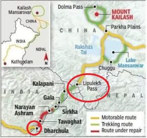
LIPULEKH PASS
- Himalayan pass.
- Near the Chinese trading town of Taklakot (Purang) in Tibet
- Used since ancient times by traders, mendicants and pilgrims transiting between India and Tibet.
- Links the Byans valley of Uttarakhand, India with the Tibet Autonomous Region of China, and forms the last territorial point in Indian territory.
- The Kailash Mansarovar Yatra, a Hinduism pilgrimage to Mount Kailash and Lake Manasarovar, traverses this pass.
- Presently open for cross-border trade every year from June through September.
- Also known as Qiangla or Tri-Corner is a high altitude mountain pass situated in the western Himalayas with a height of 5,334 metre or 17,500 feet.
- International mountain pass between India, China and Nepal.