INDIA STATE OF FOREST REPORT-2021
INDIA STATE OF FOREST REPORT-2021
NEWS
The Ministry of Environment, Forests and Climate Change (MoEFCC) has released the India State of Forest Report (ISFR) 2021.
HIGHLIGHTS
- India witnesses increase in Forest and tree cover with an additional cover of 1,540 square kilometres over the past two years.
- Forest cover has increased from 21.67%
- Tree cover has increased by 721 sq km.
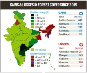
- Telangana (3.07%), Andhra Pradesh (2.22%) and Odisha (1.04%) have shown the highest increase in forest cover
- Five states in the Northeast – Arunachal Pradesh, Manipur, Meghalaya, Mizoram and Nagaland have all shown loss in forest cover.
- States with Highest Forest Area/Cover are Madhya Pradesh Arunachal Pradesh, Chhattisgarh, Odisha and Maharashtra.
- Mizoram, Arunachal Pradesh, Meghalaya, Manipur and Nagaland top five States in terms of forest cover as percentage of total geographical area
- Mangroves have shown an increase of 17 sq km. India’s total mangrove cover is now 4,992 sq km.
- 46% of the forest cover is prone to forest fires. Out of this, 2.81% is extremely prone, 7.85% is very highly prone and 11.51% is highly prone.
- By 2030, 45-64% of forests in India will experience the effects of climate change and rising temperatures.
- Forests in all states (except Assam, Meghalaya, Tripura and Nagaland) will be highly vulnerable climate hot spots. Ladakh (forest cover 0.1-0.2%) is likely to be the most affected.
- The total carbon stock in the country’s forests is estimated at 7,204 million tonnes, an increase of 79.4 million tonnes since 2019.
- Bamboo forests have grown from 13,882 million culms (stems) in 2019 to 53,336 million culms in 2021.
CONCERNS EXPRESSED
- 1,582 sq km decline in moderately dense forests, or “natural forests”.
- The decline shows a degradation of forests in the country.
- The forest cover in the region has shown an overall decline of 1,020 sq km in forest cover.
- The Northeast states account for 7.98% of total geographical area but 23.75% of total forest cover.
- The decline in the Northeastern states has been attributed to a spate of natural calamities, particularly landslides and heavy rains, in the region as well as to anthropogenic activities such as shifting agriculture, pressure of developmental activities and felling of trees.
MAHITI FOR PRELIMS
1) India State of Forest Report
- Assessment of India’s forest and tree cover, published every two years by the Forest Survey of India under the MoEFCC.
- The first survey was published in 1987, and ISFR 2021 is the 17th.
- Compiles data computed through wall-to-wall mapping of India’s forest cover through remote sensing techniques.
2) Classification of Forest
- Very Dense Forest – tree canopy density of 70 per cent or above
- Moderately Dense Forest – tree canopy density of 40 per cent or above but less than 70 per cent
- Open Forest – tree canopy density of 10 per cent or above but less than 40 per cent
- Scrub – tree canopy density less than 10 per cent(surveyed but not categorised as forests)
3) Tree cover – tree patches of size less than one hectare occurring outside the recorded forest area. This covers trees in all formations including scattered trees.
4) Forest area – Denotes the legal status of the land as per the government records, whereas the term ‘forest cover’ indicates presence of trees over any land.
5) Forest carbon – amount of carbon that has been sequestered from the atmosphere and is now stored within the forest ecosystem, mainly within living biomass and soil, and to a lesser extent also in dead wood and litter.