Published on: February 16, 2022
NEW GEOSPATIAL DATA GUIDELINES
NEW GEOSPATIAL DATA GUIDELINES
NEWS
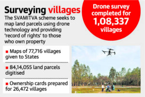
India plans to prepare digital maps of all its 6,00,000 villages and pan-India 3D maps will be prepared for 100 cities, Union Minister of State for Science and Technology said at an event to mark a year of the updated geospatial policy guidelines. It will help SVAMITVA scheme
DETAILS
WHAT IS GEO-SPATIAL DATA
- Also known as “spatial data”
- Represents the data-linked to features or objects on the Earth’s surface
- Referenced to locations on the earth (some portion of data is spatial)
- Can be
- Static, like the location of a road, an earthquake event, malnutrition among children, etc.
- Dynamic like a moving vehicle or pedestrian, the spread of an infectious disease.
- Examples in daily lives – food delivery apps like Swiggy or Zomato, e-commerce app like Amazon, Weather apps, etc
WHAT INFORMATION IS AVAILABLE
- Location information
- Attribute information (the characteristics of the object, event, or phenomena concerned): For example, in addition to the spatial information of building it also provides other information like the number of stories in the building, number of owners, etc.
- Temporal information or the time at which the location and attributes exist
IN INDIA
- Till recently, the government had a near-monopoly regarding the collection, storage, use, sale, dissemination of geo-spatial data and mapping. This was because of concerns over internal as well as external security threats.
- For example, Only government-run agencies such as the Survey of India, Defence and Home Ministries were allowed to use geospatial data.
- The private companies require approval from different departments as well as the Defence and Home Ministries. Then only, they were able to collect, create or disseminate geospatial data.
- So there is a lack of private participation in Geographic Information System (GIS) mapping in India.
- India built its own navigation system known as Indian Regional Navigation Satellite System (IRNSS) or NavIC
- Building geospatial portals like Bhuvan portal, Meteorological and Oceanographic Satellite Data Archival Centre (MOSDAC) of ISRO.
NEW GUIDELINES
- Geospatial data will be freely available in India, specifically for Indian companies.
- The companies can self-attest to government guidelines and start using geospatial data.
- Restrictions under the present policy:
- Only Indian entities can use terrestrial mapping and surveys.
- The data generated also needs to be owned and stored in India.
- High-resolution data—finer than 1 m horizontally and 3 m vertically—will still remain restricted.
- Except for sensitive defence or security-related data, all other data can be accessed by Indian companies.
- With this policy, Indian companies will be able to set up location services like Google Map in India.
NOTE :
SVAMITVA SCHEME